Troy Kimmel
UT University / Incident Response Meteorologist
Member, Campus Safety and Security Committee
Senior Lecturer, Department of Geography and the Environment
tkimmel@utexas.edu
Severe Weather Alerts
Visit NWS Tweets
In a Change to the Forecast, Due to the Upper Level Low Pressure Area to Our East and the Fact It Is Going to Move Little in the Next 24 Hours, Isolated Rain Showers Possible Today and Widely Scattered Rain Showers/Thunderstorms Possible Tomorrow; A Drier and More Stable Weather Pattern Tomorrow Night through the Remainder of the Weekend and Next Week; Texas Heat Makes a Big Return by Middle Part of Next Week (Fr/09May2025)
Any questions? Contact me:
tkimmel@utexas.edu
troy@troykimmelweather.com
On Twitter, follow me and
activate notifications for my tweets…
@troykimmelwx
Courtesy of WeatherStem, check out the latest CURRENT
University of Texas weather conditions and see the live camera at THIS LINK.
On weekends and other holidays when this site is not updated,
I encourage you to check out the latest NWS Austin-San Antonio forecast
for metro Austin at THIS LINK.
Remember that, in periods of severe/inclement weather, it is YOUR
responsibility to always have at least two methods of getting current weather information..
.. follow me AND activate notifications on X/Twitter .. @troykimmelwx .
.. have your NWS All Hazards Weather Radio properly set AT ALL TIMES so
it can receive and activate/alarm when NWS watches and warnings are issued ..
.. register to receive emergency updates at https://warncentraltexas.org/
.. make sure the WEA alerts are activated in your settings on your smart phone ..
.. go to the NWS Austin-San Antonio website at weather.gov/ewx ..
.. go to http://mesonet.agron.iastate.edu/cgi-bin/afos/retrieve.py?pil=warewx&limit=20&fmt=html for a chronological text listing (most current
at the top but note the page doesn’t auto-refresh, you must refresh page manually)
of all NWS Austin-San Antonio watches, advisories and warnings..
—-
AUSTIN / IH35 CORRIDOR
7-DAY FORECAST WEATHER HAZARDS…
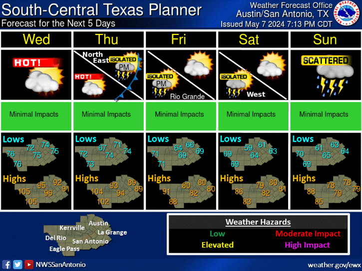
Fr/09May… A few rain showers mid/late afternoon… Otherwise no weather hazards.
Sa/10May… Lightning with any isolated thunderstorms midday to late afternoon..
Su/11May… No weather hazards expected..
Mo/12May… No weather hazards expected..
Tu/13May… No weather hazards expected..
We/14May… Excessive Heat with Highs Near 100 F..
Th/15May… Excessive Heat with Highs Near 100 F..
—-
AUSTIN / IH35 CORRIDOR
SEVEN DAY WEATHER HEADLINES
AND MY 7 DAY FORECAST CONFIDENCE …
(1) While somewhat cooler and drier surface air is moving into the area from the north, the upper level low pressure area that crossed south Texas with the strong thunderstorms yesterday afternoon and night (and our light rain evening into the nighttime hours) has found its way into east Texas and Louisiana; In a major change to the forecast, it now appears that it will sit there or only move eastward slightly and continue to spin counterclockwise and have an effect locally on our IH35 corridor a little longer than I had anticipated.
Based on this, as the upper level low spins counterclockwise, we need to watch two disturbances moving into our area from the north (think about them like “spokes” in a bicycle wheel with the bicycle wheel centered over east Texas and Louisiana).. the first being mid afternoon today and another one due for the mid to late afternoon hours tomorrow. Let’s deal with these disturbances and their potential impact individually..
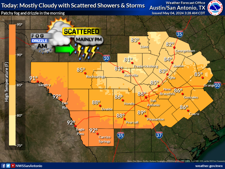
TODAY, in the 2 to 3pm hour (with our peak heating of the day), a weak disturbance will move into area from the north and will perhaps cause the development of isolated to widely scattered rain showers (20% rain; rainfall of trace amounts). The latest high resolution short range guidance shows this activity not lasting very long (4-5pm) with only a few sprinkles expected here on the ground below the mid level clouds expected to produce them. While I’ll need to watch closely, I do not see a lightning threat with this disturbance. No precipitation expected beyond 5pm today with a quiet evening and night weather wise.
TOMORROW, by late morning into midday, another slightly stronger disturbance will move into the area from the north and will cause the development of isolated rain showers and the possibility of a thunderstorm or two with an associated lightning threat (20% rain, rainfall of less than 0.20 inch). The latest high resolution short range guidance shows this activity remaining widely scattered until about 4 to 5pm and ending thereafter. No precipitation expected beyond 6pm with a quiet evening and night weather wise.
(2) We finally see a drier and more stable weather pattern by tomorrow night through the remainder of the weekend and through much of next week as upper level high pressure becomes established over our area. Temperatures will be warming significantly with afternoon high temperatures for the IH35 corridor reaching near the 100 degree mark by the middle into latter part of next week.
Based on NWS/Weather Prediction Center data and guidance, my forecast is for less than 0.05 inch of rainfall (mainly late this afternoon into this evening), on average, for our IH35 corridor counties through the 7 day forecast period which ends in the early morning hours next Thursday.
MY LOCAL FORECAST CONFIDENCE OVER THE NEXT SEVEN DAYS…
A high to very high confidence forecast through the next seven days.
—
Troy’s Weather Forecast for Austin and the IH35 Corridor
Updated Friday / 09 May 2025
TODAY (09May)…. Mostly sunny. Isolated rain showers between 2pm and 6pm. Rainfall, where it occurs given a less than 20% chance of rain at any given location, will average trace amounts. High 83. Northerly wind increasing to 5 to 12 mph with a few higher gusts.
TONIGHT…. Mostly clear. Low 61. Northerly wind 5 to 12 mph with a few higher gusts.
SATURDAY (10May)…. Mostly clear in the morning then partly cloudy in the afternoon. Widely scattered rain showers and thunderstorms with an associated lightning threat between 11am and 6pm. Rainfall, where it occurs given a 20% chance of rain at any given location, will average less than 0.20 inch. High 80. Northerly wind 5 to 12 mph with a few higher gusts.
SATURDAY NIGHT…. Partly cloudy. Low 59. North northeasterly wind 5 to 10 mph becoming light northeasterly.
SUNDAY (11May)…. Mostly sunny. High 83. Calm wind becoming light northerly.
SUNDAY NIGHT…. Mostly clear. Low 56. Light northeasterly wind becoming light.
MONDAY (12May)…. Sunshine. High 90. Light wind becoming southwesterly 4 to 8 mph.
MONDAY NIGHT…. Mostly clear. Low 63. South southeasterly wind 4 to 8 mph becoming light.
TUESDAY (13May)…. Mostly sunny. High 97. South southwesterly wind 5 to 12 mph with some higher gusts.
TUESDAY NIGHT…. Mostly clear. Low 70. Southerly wind 5 to 10 mph becoming light.
WEDNESDAY (14May)…. Mostly sunny. High 100. South southwesterly wind 5 to 12 mph.
WEDNESDAY NIGHT…. Mostly clear. Low 70. Southerly wind 5 to 10 mph.
THURSDAY (15May)…. Mostly sunny. High 99. Southerly wind 5 to 12 mph.
NATIONAL WEATHER SERVICE / CLIMATE PREDICTION CENTER (CPC)
8 TO 14 DAY OUTLOOK
Valid Friday / 16 May 2025 through Thursday / 22 May 2025
Temperature… Above Average
Precipitation… Slightly Above Average
NATIONAL WEATHER SERVICE / CLIMATE PREDICTION CENTER (CPC)
3 TO 4 WEEK OUTLOOK (Updated on Friday/02May2025)
Valid Saturday / 17 May 2025 through Friday / 30 May 2025
Temperatures… Better Chances of Higher Than Normal
Precipitation… Better Chances of Near to Slightly Below Normal
AUSTIN / IH35 CORRIDOR SUNRISE/SUNSET TIMES…..
Today (Fr/09May)……………………………………. 6:41 am / 8:14 pm (+ 1 minutes)
Tomorrow (Sa/10May)…………………………….. 6:40 am / 8:15 pm (+ 2 minutes)
tk
Today's Forecast
Five Day Planner