Troy Kimmel
UT University / Incident Response Meteorologist
Member, Campus Safety and Security Committee
Senior Lecturer, Department of Geography and the Environment
tkimmel@utexas.edu
Severe Weather Alerts
Visit NWS Tweets
A More Unsettled Period with Increased Slowly Increasing Rain and Storm Chances Through the End of the Week with Thunderstorm Chances Peaking As a Cold Front Passing Saturday into Saturday Night and Sunday with Much Cooler Temperatures to Follow (We/17Apr2024 Update)
Audio Weather Webcast
(Includes My Complete Forecast Reasoning)
Updated Wednesday / 17 April 2024
… Not Available Today …
Contact me:
tkimmel@utexas.edu
troy@troykimmelweather.com
On Twitter, follow me and
activate notifications for my tweets…
@troykimmelwx
On weekends and other University holidays when this site is not updated,
I encourage you to check out the latest NWS Austin-San Antonio forecast
for metro Austin at this link.
In times of severe and/or inclement weather, you can follow the latest area
watch, advisory and warning updates from our local NWS Austin-San Antonio
office through their website.. or by reading the actual text products (always
the most recent at the top of the page) through this link which is courtesy of
the Iowa Environmental Mesonet. Always check the date and time of issuance
of these NWS text products since, in periods of tranquil weather, the latest
products may be outdated and/or expired.
—-
AUSTIN / UNIVERSITY OF TEXAS
WEATHER HAZARDS THROUGH 12 MIDNIGHT TONIGHT…
… No Weather Hazards Expected …
—-
AUSTIN / UNIVERSITY OF TEXAS WEATHER
SEVEN DAY WEATHER HEADLINES
AND MY 7 DAY FORECAST CONFIDENCE …
(1) With south southeasterly surface winds and increased low level moisture now in place, we’re seeing, under a mostly cloudy sky, some patchy light drizzle on the IH35 corridor.
(2) An approaching upper level low pressure storm system out west has allowed an associated cold front to pull up stationary just to our west It will likely remain to our west through the end of the week. As atmospheric instability increases and combines with rich Gulf moisture and atmospheric lift from passing upper air low pressure disturbances, we’ll see still slim rain and storm chances beginning late tomorrow into early tomorrow night and again by Friday night.
(3) A stronger upper level disturbance will finally allow the cold front to surge southeastward across our IH35 corridor Saturday into Saturday night with the best chance of rain and storms even potentially heavier rain along with a threat of lightning. As the front moves southeast to the Texas coast, lingering post frontal clouds and rain and isolated storm chances will continue along with much cooler temperatures on late Saturday night into Sunday.
(4) As surface high pressure builds into our area in the wake of the front, clouds will break by Sunday night into Monday with sunshine and a little warmer temperatures returning.
Based on NWS/Weather Prediction Center guidance, 1.00 to 1.50 inch of rainfall is forecast for our IH35 corridor over the next seven day forecast period (specifically, focusing on the Thursday through Sunday morning period).
MY FORECAST CONFIDENCE OVER THE NEXT SEVEN DAYS…
High forecast confidence falling back to medium to high by Saturday and Sunday.
—
Troy’s Weather Forecast for Austin and South Central Texas
Updated Wednesday / 17 April 2024
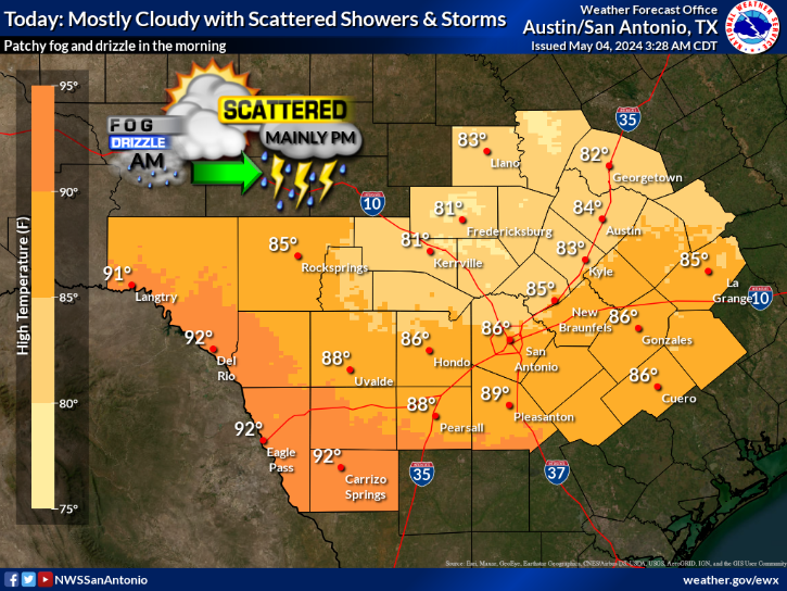
TODAY (17Apr)…. Patchy morning fog and drizzle. Morning low clouds becoming partly to mostly cloudy. High 88. Southerly wind 5 to 12 mph.
TONIGHT…. Becoming mostly cloudy. Low 71. South southeasterly wind 5 to 10 mph.
THURSDAY (18Apr)…. Morning low clouds becoming partly to mostly cloudy. Widely scattered rain showers and thunderstorms with an associated lightning threat after 4pm. Rainfall, where it occurs given a 20% chance of rain at any given location, will average 0.10 inch or less. High 88. Southerly wind 5 to 12 mph.
THURSDAY NIGHT…. Becoming mostly cloudy. Widely scattered rain showers and thunderstorms with an associated lightning threat before midnight. Rainfall, where it occurs given a 20% chance of rain at any given location, will average 0.10 inch or less. Low 70. South southeasterly wind 5 to 12 mph.
FRIDAY (19Apr)…. Morning low clouds becoming partly to mostly cloudy. High 86. East southeasterly wind 5 to 12 mph.
FRIDAY NIGHT…. Becoming mostly cloudy. Widely scattered rain showers and thunderstorms with an associated lightning risk. Rainfall, where it occurs given a 20% chance of rain at any given location, will average less than 0.10 inch. Low 68. East southeasterly wind 5 to 12 mph.
SATURDAY (20Apr)…. Cloudy. Scattered rain showers and thunderstorms before 2pm then becoming more numerous with an associated lightning risk as a cold front passes mid into late afternoon. Rainfall, where it occurs given a 50% chance of rain at any given location before 2pm and 70% after 2pm, will average 0.50 inch. High 79. East southeasterly wind 8 to 15 mph shifting northerly by late afternoon.
SATURDAY NIGHT…. Cloudy and cooler. Rain showers and thunderstorms with an associated lightning risk. Heavy rain at times. Rainfall, where it occurs given a 90% chance of rain at any given location, will average 0.50 to 0.75 inch. Low 55. Northerly wind 8 to 15 mph with some higher gusts.
SUNDAY (21Apr)…. Mostly cloudy and cooler. Scattered rain showers and isolated thunderstorms mainly in the morning with an associated lightning risk. Rainfall, where it occurs given a 40% chance of rain at any given location, will average 0.25 inch. High 67. Northerly wind 8 to 15 mph with some higher gusts.
SUNDAY NIGHT…. Partly to mostly cloudy. Low 54. North northeasterly wind 5 to 12 mph.
MONDAY (22Apr)…. Some cloudsc early otherwise becoming mostly sunny. High 75. East northeasterly wind 5 to 10 mph.
MONDAY NIGHT…. Partly cloudy. Low 58. Light easterly wind.
TUESDAY (23Apr)…. Partly cloudy. High 81. Light wind becoming southerly 5 to 12 mph.
NATIONAL WEATHER SERVICE / 8 TO 14 DAY OUTLOOK
Valid Wednesday / 24 April 2024 through Tuesday / 30 April 2024
Temperatures… Above Average
Precipitation… Above Average
AUSTIN SUNRISE/SUNSET TIMES…..
Today (We/17Apr)………………………. 7:01 am / 8:00 pm
Tomorrow (Th/18Apr)…………………. 7:00 am / 8:01 pm
Today's Forecast
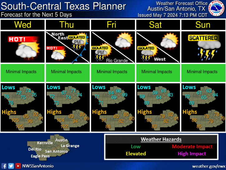
Five Day Planner